


Charreau, J.; Blard, P.H.; Lavé, J.; Dominguez, S.; Li, W.S.
Tectonophysics, 2023, 848, 229702
Voir en ligne : https://doi.org/10.1016/j.tecto.2022.229702
Abstract :
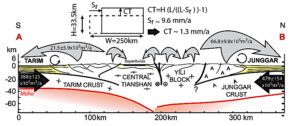
The Tianshan mountains have complex and variable topography and documenting their growth is important for understanding both intracontinental mountain building and the evolution of the global climate. We investigate whether this topography is in equilibrium with crustal influx (thickening) and sediment outflux (denudation). Based on literature, we estimate that the eastern Tianshan has been subject to a total crustal shortening rate of ~9.4 mm/a across the Kuitun–Kuche transect, implying ~1.3 mm/a of crustal thickening and a total crustal influx of ~9 × 10⁷ m3/a. We measured in-situ cosmogenic 10Be concentrations in modern river sands of 34 catchments to constrain recent (0–6 ka) basin-averaged denudation rates within the range and on its two flanks. Denudation rates range from 0.020 ± 0.002 to 0.53 ± 0.07 mm/a, averaging 0.20 ± 0.04 and 0.11 ± 0.02 mm/a in the north and south, respectively; these rates correspond to respective total sediment outfluxes of (542 ± 69) × 104 and (164 ± 24) × 104 m3/a. To ensure that these values can be compared to Pleistocene tectonic rates, we
reconstructed Pleistocene denudation rates in seven of the studied basins. For this, we determined inherited insitu cosmogenic 10Be concentrations from 11 cosmogenic depth profiles of abandoned fluvial terraces deposited in the Tianshan piedmonts. These data indicate that denudation rates have been relatively steady since the Pleistocene and thus that recent and Pleistocene sediment fluxes can be compared. These results show that crustal thickening outpaced denudation and sediment outflux by a factor of ~10. Therefore, the Tianshan topography is not in dynamic equilibrium and is growing, even if materials are being subducted into the mantle. Consequently, to sustain this disequilibrium, the range grew laterally. This lateral growth and the inheritance of structures and basins are likely responsible for the complex topography of the range.